|
|
|
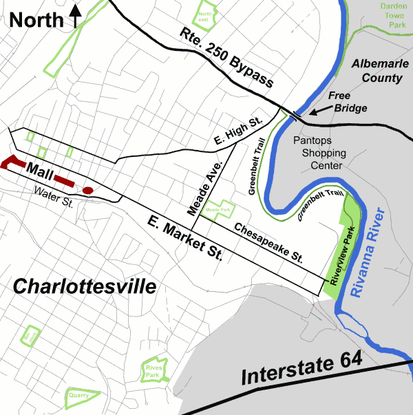
| The Rivanna River Greenbelt Trail is a part of
the Greenbelt trail system the City of Charlottesville, Virginia has designated
on its Future Land Use Plan. This segment of the Greenbelt travels approximately
1.25 miles from its beginning in Riverview Park in a northern direction
along the scenic Rivanna River, ending at Free Bridge at Route
250. At this point visitors may continue onto the Rivanna Trail,
a path of right-of-ways across private property maintained by the Rivanna
Trails Foundation. A visitor may park in
the parking area at Riverview Park.
In addition to the initial trail, completed in May 1993, a river loop of
the trail has been constructed in Riverview Park. This segment
of the trail, measuring about 0.8 miles, also has its beginning in Riverview
Park. This segment of the Greenbelt, completed in June 1994, makes
a loop about 100 yards to the east of the initial segment and skirts the
banks of the Rivanna River. The Greenbelt loop joins up with the
initial Greenbelt segment as it travels northward as one exits Riverview
Park. (Map)
The uniqueness of the trail becomes quite apparent when one begins the trek on its brown stone surface. The trail, which is accessible to persons with disabilities, is excellent for bikers and joggers alike. The Trail is measured with quarter mile markers to assist joggers and walkers. Good fishing spots are available at many areas along the trail. (A fishing pier that was built for persons with disabilities was damaged beyond repair during Tropical Storm Fran in September 1996 and had to be removed.) Visitors to the trail are often treated to sightings of deer, beaver, rabbits and other wildlife one would not expect to see in a city park. This trail, the first segment of the city's Greenbelt system to be built, uses the scenic and recreational resources of the Rivanna River to provide an enjoyable outing for area residents and visitors alike. As you walk along the trail, please notice the duck boxes that were placed by the Virginia Chapter of Ducks Unlimited. All in all, an enjoyable day can be had at the Rivanna Greenbelt Trail. |
| Thomas Jefferson became interested in navigation
on the Rivanna River (known originally as the "River Anna") and made a
study of the river in 1763. At his instigation, the channel was cleared
of rocks and debris and it was said to be navigable for cargo by canoes
and bateaux as far as Milton. The Three-Notched Road, now Main Street,
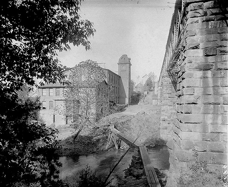
crossed the river near the site of the Woolen Mills. The Rivanna
River was an important transportation route during the American Revolution.
Sometime around the 1820's, Charlottesville gave its ports on the Rivanna the name "Pireus", after the port City of Athens. This area is now better known as "Woolen Mills". The Charlottesville Woolen Mills (historic Holsinger photo: small or large), which manufactured cloth for the Confederate soldiers' uniforms during the Civil War, was burned by Union soldiers. Rivanna Park sits on the land near the Woolen Mills and Dam that was known as "Pireus". |
 |
| FROM VISITOR'S CENTER: Take Route 20 North
to Monticello Avenue to right on Avon Street to right on Market Street
to left on Riverside Avenue to Riverview Park.
FROM 250 BYPASS: Take East High Street to left on Meade Avenue to left on East Market Street to left on Riverside Avenue to Riverview Park. |
 |
| Holsinger Studio Collection, Special Collections Department, University of Virginia Library; |
| Rivanna Trails Foundation |
Riverview Park & Rivanna Greenbelt
Home
Parks and Grounds Home
Revised 10/24/02 by Stowe Keller
 Charlottesville
City Home Page
Charlottesville
City Home Page